Log in
All resources
Create a design
9,296 Free Artworks of Map Collection
bibliothèque nationale de france
metropolitan museum of art
l. massard
department of photographs, metropolitan museum of art
heliogravure
maps from gallica
guides joanne
1667 sanson map of africa
print
statens museum for kunst
bibliothèque nationale de france
cartouches by sanson family
maps from gallica
guides joanne
maps from gallica
guides joanne
maps from gallica
guides joanne
prints by oluf olufsen bagge in the statens museum for kunst
etching and copper engraving
carte de moscovie by guillaume de l'isle (1706)
university of washington
national archives and records administration
solon m. allis
high renaissance,renaissance
a map of imola (rcin 912284)
context files from gallica
pieter van der keere
department of photographs, metropolitan museum of art
l. massard
department of photographs, metropolitan museum of art
l. massard
department of photographs, metropolitan museum of art
l. massard
department of photographs, metropolitan museum of art
l. massard
department of photographs, metropolitan museum of art
l. massard
department of photographs, metropolitan museum of art
l. massard
department of photographs, metropolitan museum of art
l. massard
ignatius van der stock
1661 paintings
department of photographs, metropolitan museum of art
l. massard
department of photographs, metropolitan museum of art
l. massard
department of photographs, metropolitan museum of art
l. massard
cornell: persuasive cartography: the pj mode collection
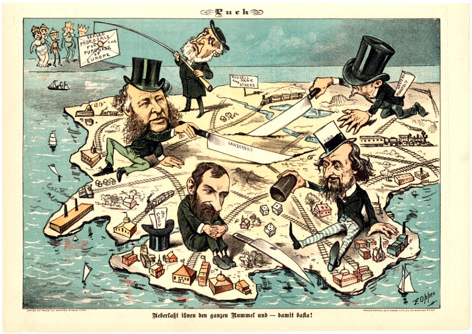
puck, 1882
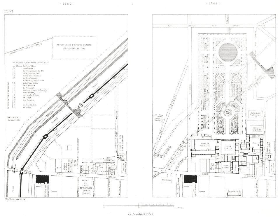
engravings of palais royal by theodor hoffbauer
lithographs of paris
eran laor cartographic collection
maps of rügen by eilhard lubinus
maps of budapest by joris hoefnagel
eran laor cartographic collection
christian benjamin glassbach
matthias oesterreich
prints by matteo greuter in the statens museum for kunst
copper
german renaissance,northern renaissance
details of the ambassadors (holbein)
topographia helvetiae, rhaetiae et valesiae (1654) engravings
baroque
ndl-dc 9369963 dainihon rekishi nishiki-e
utagawa yoshikazu
dzieje krakowa (1911)
lajkonik
chatham dockyard
samuel buck
maps in the stadsarchief amsterdam
hendrik de leth
lakes of haute-garonne
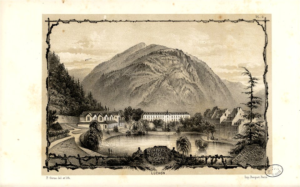
pierre gorse
waterfalls of the pyrenees in art
lakes of haute-garonne
prints by matteo greuter in the statens museum for kunst
copper
mainz in the 1730s
old maps of mainz
château de cheverny
étienne martellange
book covers from the british library mechanical curator collection
the earth and its inhabitants
ismailïa. a narrative of the expedition to central africa for the suppression of the slave trade (1874)
diagrams, plots and charts from the british library mechanical curator collection
book covers from the british library mechanical curator collection
the earth and its inhabitants
utagawa kuniteru ii
ukiyo-e
romanticism
john martin
eran laor cartographic collection
willem albert bachiene
prints, drawings and watercolours of the royal museums greenwich
1796 maps
atlas schoemaker-friesland
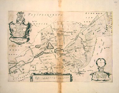
maps of smallingerland
atlas schoemaker-friesland
maps of dantumadiel
via dei malcontenti
pianta della catena
jacques burkhardt scientific drawings
emys
drawings by niels larsen stevns in the statens museum for kunst
print
ndl-dc 1312546 nishiki-e
utagawa kuniteru
atlas geographico del reyno de españa e islas adjacentes (1757)
18th-century maps of andalusia
adrianus johannes bik
diponegoro
atlas geographico del reyno de españa e islas adjacentes (1757)
18th-century maps of madrid
painting of vital cvirka on stamps
2013 postage stamps of belarus
women of the world from the british library mechanical curator collection
the earth and its inhabitants, vol. vi: asia, vol. i
bibliothèque nationale de france
1667 sanson map of africa
bibliothèque nationale de france
1667 sanson map of africa
maps from gallica
guides joanne
bibliothèque nationale de france
1667 sanson map of africa
maps of córdoba by braun & hogenberg
bibliothèque nationale de france
bibliothèque nationale de france
guillaume sanson
bibliothèque nationale de france
1667 sanson map of africa
maps of portugal by fernando álvares seco
bibliothèque nationale de france
maps of brussels by braun & hogenberg
bibliothèque nationale de france
bibliothèque nationale de france
1667 sanson map of africa
bibliothèque nationale de france
guillaume sanson
atlas sive cosmographicae (gerardus mercator, 1630)
1630s maps of china
maps of bordeaux by braun & hogenberg
bibliothèque nationale de france
maps of cagliari by braun & hogenberg
views of cagliari
bibliothèque nationale de france
1667 sanson map of africa
british library king's topographical collection
john & josiah boydell
arrival of the hungarians by árpád feszty
oil
everett d. graff collection of western americana
the adventures of captain bonneville
novopavlovka
moritz vebel
17th-century maps of the mediterranean sea
portolan charts made in the 17th century
history of westphalia in the lwl-museum für kunst und kultur
maps of arnsberg by braun & hogenberg
maps from gallica
guides joanne
bibliothèque nationale de france
cartouches by tomas lópez
map of europe by guillaume sanson (1674)
bibliothèque nationale de france
maps from gallica
guides joanne
images released by british library images online, march 2014
totius neobelgii nova et accuratissima tabula (1710)
maps of caprarola by braun & hogenberg
bibliothèque nationale de france
bibliothèque nationale de france
guillaume sanson
mappe-monde geo-hydrographique (sanson and jaillot, 1674)
bibliothèque nationale de france
carta hydrographica y chorographica de las yslas filipinas... - por... el pe pedro murillo velarde - btv1b53066953z
baroque painting
map of the circle of lower saxony by sanson
bibliothèque nationale de france
carte de france instructive et amusante divisée en quatrevingt six départements - btv1b84949605
bibliothèque nationale de france
map of europe by guillaume sanson (1674)
bibliothèque nationale de france
map of the circle of upper saxony by sanson
bibliothèque nationale de france
maps from gallica
guides joanne
map of europe by guillaume sanson (1674)
bibliothèque nationale de france
maps of paris by braun & hogenberg
bibliothèque nationale de france
map of europe by guillaume sanson (1674)
bibliothèque nationale de france
carte de france instructive et amusante divisée en quatrevingt six départements - btv1b84949605
bibliothèque nationale de france
sanson maps of south america
south america in the 1690s
maps from gallica
guides joanne
media contributed by university of illinois urbana-champaign university library
carte de barbarie, nigritie, guinée par guillaume delisle (1707)
scenes from every land, second series (1909)
photographs by arnold henry savage landor
siege of leiden
maps of leiden
parc des quinconces (bagnères-de-luchon)
thermes chambert in art
6601 - 6700 of 9,296
Next page
/ 93